
Getting Around
San Diego Geography
When most people think of San Diego they are typically thinking of San Diego County, as San Diego proper, the actual city, excludes a lot of places that many would consider San Diego, such as Coronado, Del Mar, or Chula Vista. San Diego County is massive and includes eighteen incorporated cities, dozens of unincorporated towns, a national forest, a desert state park, and a giant marine corps base. To us, this is all San Diego.
We have lumped a few areas together
- North County: refers to Del Mar and the beach towns north of this (Solana Beach, Carlsbad, Encinitas, Oceanside), as well as Escondido.
- East County: refers to La Mesa and everything east of this (Poway, El Cajon, Lemon Grove, Spring Valley, Santee, Ramona, Alpine, Jamul).
- South Bay: refers to National City, Chula Vista, Imperial Beach, Bonita, and all the way south to the Mexico border

North Park: Certified hipster neighborhood bordering the northeast corner of Balboa Park – with bars, breweries, restaurants, coffee shops and vintage clothing stores, North Park is a highlight of San Diego city life
Ocean Beach: A classic Southern California beach town stuck in some sort of decade that is not this decade and all the better for it. Grimy yet somehow charming – OB is a lively beach town.
Pacific Beach: Hordes of wandering, sunburnt youths in their twenties stopping from bar to bar after their beach volleyball party is what PB is all about. A lot of fun if you’re up for it.
Point Loma: A mostly residential neighborhood with a strip of bayside activities to the east, including Liberty Station, and beautiful Sunset Cliffs and Cabrillo National Monument to the east – Point Loma has a lot more going on than meets the eye.
Sorrento Valley & Mira Mesa: Suburban housing and sprawling office parks east of San Diego, this area hosts many of the biggest brewing operations for local beer companies.
South Park and Golden Hill: Quaint tree lined streets and cute restaurants and shopping give South Park and Golden Hill the most neighborhoody of neighborhood feelings. Bordering the east side of Balboa Park, but still feels secluded and calm.
University Heights: Family-friendly neighborhood with a small strip of local businesses located just north of North Park, University Heights may not be a destination, but they like to keep it that way.
San Diego Neighborhood Guide
Bankers Hill & Balboa Park: Balboa Park is the shining gem of San Diego and Bankers Hill borders it to the west – a refined urban neighborhood with hidden suspension bridges and canyons near elevated restaurants and breweries.
Barrio Logan: Historically Mexican neighborhood south of downtown, Barrio Logan has a lively strip of locally owned restaurants and bars, as well as the famous Chicano Park.
Clairemont & Convoy District: The best eating neighborhood in San Diego – Clairement and the famous Convoy Street have so many delicious restaurants scattered throughout their strip malls it is hard to comprehend. Any Asian food you can imagine and most of it authentic.
Coronado: A wealthy beach town located conveniently a bridge away from San Diego, Coronado is idyllic and beautiful. The famous Hotel Del Coronado centers the town.
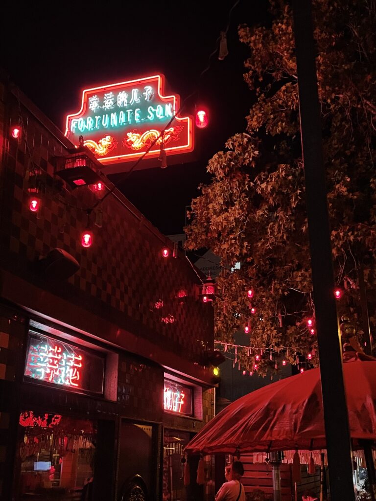
Gaslamp & East Village: The urban core of San Diego with high rise apartment and office buildings, Petco Park, the Convention Center, and enough bars, restaurants, and hotels to fill two cities, this place is always awake and always busy. It is geared towards tourists so take that into account.
Hillcrest: The gayborhood of San Diego, Hillcrest is a good time all the time and one of the liveliest neighborhoods in the city. Borders Balboa Park to the north so easily accessible after a day in the park.
La Jolla: The wealthy neighborhood that sits at San Diego’s northernmost border, La Jolla has expensive shopping, art galleries, restaurants, and a cove full of seals that bite tourists sometimes.
Little Italy: The nightlight spot outside of downtown San Diego or possibly surpassing it, Little Italy is a bustling neighborhood of bars and restaurants just north of downtown.
Mid City & City Heights: A broad region in central/eastern San Diego that is more diverse and local than the more written about parts of the city, City Heights and the region around El Cajon Boulevard has some of the truly hidden gems of the city.
Mission Beach: Wide beaches, strip of beach bars, an amusement park, and Mission Bay – a giant man made aquatic park.
Mission Hills & Old Town: Mission Hills is a wealthy enclave with a handful of intimate restaurants and lovely streets to gaze at mansions, just up the hill from Old Town, the historic beginning of San Diego.
Normal Heights & Kensington: Nestled across the highway from the hustle and bustle of North Park, Normal Heights and Kensington are self-contained neighborhoods able to create their own artsy charm and distinctively local feel.
San Diego Transportation
Most parts of San Diego are spread out. The neighborhoods around Balboa Park, stretching all the way south to Downtown, are in a more dense grid, but even here walking from neighborhood to neighborhood can be far. Most people in San Diego get around by car. Parking can be a hassle in the busier neighborhoods, such as Downtown and Little Italy. There is a reliable and clean trolley that runs a few routes in the city and hits a lot of the bigger destinations so taking this whenever feasible is a great idea. If you’re savvy, the buses in San Diego are legit and go literally everywhere – you just have to know how to read a bus schedule.
Here are your options for getting around:
Drive/Rideshare
NORTH SOUTH TRAFFIC
The major north-south highways in San Diego are the 5, the 805, and the 15. The 5 and 805 run essentially parallel and are interchangeable – one runs west of Balboa Park and one runs east, then the reconnect. The 15 branches of the 805 and heads more east as you go north – serving Escondido, Temecula, and eventually heading into the Inland Empire around Riverside County.
EAST WEST TRAFFIC
PARKING
Parking in Little Italy, Seaport, Gaslamp, and East Village can be rough – take an Uber to these places if possible. The farther you get from downtown the better parking is, so it is less of a risk to just drive into these neighborhoods. Obviously, the beach in the summertime is packed to the brim (we’ve witnessed literal fist fights over beach parking in the summer), but you didn’t need us to tell you that.
Trolley

Blue Line
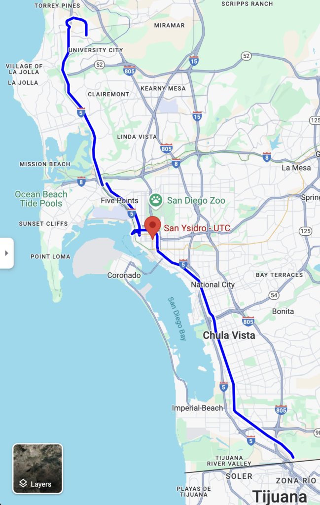
The Blue Line is probably the most useful of the trolley lines, particularly for those visiting the city. It runs north and south closest to the coast – starting at the UTC Mall in University City on the northern end and ending at the San Ysidro Border Crossing to Tijuana in the south.
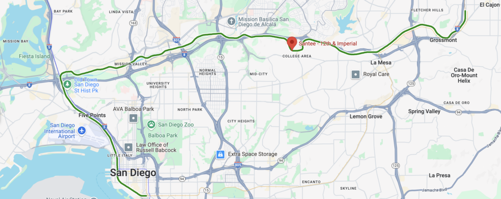
Green Line
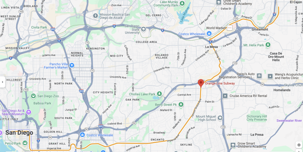
Orange Line
Bus
San Diego does have an extensive bus system if you are coordinated enough to use it. There is almost nowhere in the city that you can’t get to by bus. The best way to figure out how to use the bus is to use the MTS Trip Planner service.
Bicycle/Scooter
San Diego is becoming a bike friendly city. In the neighborhoods near Balboa Park, all the way to Downtown, Little Italy, and Seaport, there is an extensive networks of bike lanes that allow for bike commuting. There are also longer bike paths going out to the coast – to OB, Mission Bay, and even up to La Jolla.
There are electric scooters to use around San Diego, but we would only recommend these for very short trips as there are increasingly more scooter accidents these days and there are lots of dead zones for these scooters so you may find yourself lugging a scooter several blocks to get back to a legal area to ride.
Our Final Suggestion
The reality is you will probably have to drive most places in San Diego, outside of the downtown areas. Check the prices and see if an Uber makes sense. The trolley is a great addition to San Diego and we use it as much as possible, especially in going downtown for bigger events like Padres games. San Diego is not yet the bike friendliest city, but if you are staying in the neighborhoods around Balboa Park and only traveling a few blocks away biking is a great option.